AZ to ID Road Trip - Part 1
So we picked up our new fifth wheel
from the dealer, with some issues fixed and some still to be
rectified in July, (when we will be back at Indian Skies RV Resort
for a month). After a quick load of essentials and some creative
packing, we headed out on our 2 week road-trip which would get us to
Idaho in time for our next camp-hosting job.
Our first stop heading generally in a
northerly direction, was at Tonto National Monument. We have a
lifetime pass for National Parks (including National Monuments) in
the USA, so any visit to either is free of charge.
I have previously written about our
visits to sites of the Ancient Ones, and I
wanted to see how their culture differed to that of the Salado people
who settled in pit houses and cliff dwellings in the Tonto Basin area
of Arizona at about the same time as the Ancient Puebloan people.
Of the two hundred once thriving
communities in this area, we visited only one. Combining a three
mile round trip hike with a guided tour, we were shown the variety of
flora and fauna of the area which provided sustenance to those
living in the cliff dwelling above.

 The original valley floor (now a
reservoir created by the Theodore Roosevelt Dam), and the remaining
creek that flows into it, sustain mesquite, walnut and sycamore,
hillsides contain saguaro, cholla, prickly pear and jojoba (yes the
nuts provide oils and you have heard of that before in shampoo,
right?). Higher elevations provide oak, juniper, pinyon, and
ponderosa pine. Deer, rabbit and quail were a source of meat, and
cotton, squash, beans and corn were grown in the desert heat. Have I
mentioned before that the three staples of the Native Americans were
grown together for very clever reasons. The corn grew tall, the
beans used the corn stalk to grow up, and the squash leaves provided
shade for the ground, to help prevent evaporation of water.
The original valley floor (now a
reservoir created by the Theodore Roosevelt Dam), and the remaining
creek that flows into it, sustain mesquite, walnut and sycamore,
hillsides contain saguaro, cholla, prickly pear and jojoba (yes the
nuts provide oils and you have heard of that before in shampoo,
right?). Higher elevations provide oak, juniper, pinyon, and
ponderosa pine. Deer, rabbit and quail were a source of meat, and
cotton, squash, beans and corn were grown in the desert heat. Have I
mentioned before that the three staples of the Native Americans were
grown together for very clever reasons. The corn grew tall, the
beans used the corn stalk to grow up, and the squash leaves provided
shade for the ground, to help prevent evaporation of water. |
| Corn husk found at the site - much smaller corn than present day |
 |
| Sandal woven out of yucca plant leaves |
You can see how cultivation of the
land could produce food in abundance, so it is unsurprising that, by
1100, population centers across the desert Hohokam and Puebloan
communities approached their social and economic peak. Migration to
ease the pressure on resources and population was the obvious next
step. It is thought the Salado people were an extension of these
Hohokam and Puebloan groups, formed as part of that migration.
Interesting to me was the fact that there were no discernible
religious artifacts in the dwelling, no kiva, for example, so perhaps
this community came together to worship differently. Of course there
is always an element of speculation, but I find the history of the
native settlers of this continent fascinating.
 |
| map showing ancient people's of the south west and their locations |
Our next stop was Cottonwood, where we
also visited another ancient people's pueblo – Tuzigoot. The
people of the Verde river valley were the Sinagua; they also mined,
predominantly for salt; produced reddish-brown pottery, and built
their homes using stone from the area. Unlike the sites we have visited before, this community sits on a
hill, and its rooms are several stories high.


Cottonwood was originally established
as a satellite community to aid the processing of the gold, silver
and copper mined in Jerome. Once home to a population of 1,500, the
fourth largest city in Arizona, Jerome is located on a mountain, a
mile high in elevation, 15 miles to the south. It's mountains produced the ore,
but it needed to be delivered to flatter ground for processing.
Jerome clings to a mountainside
crisscrossed with obsolete mine shafts thousands of feet deep. It
still produces copper, though the mining is now via open pit
extraction, but of course the town became a ghost town over the first
50 years of the 19th century, as the need for manual labor
declined. In the hippie era of the sixties and seventies, there was
a regeneration due to an influx of artists who renovated homes and
abandoned stores to sell their wares. Today its eclectic galleries
and delightful stores and restaurants make Jerome a tourist
destination. I loved it so much we visited twice. It has the feel
of a European town, with two and three storied multicolored housing
seemingly growing out of the mountain, interspersed with gardens and
winding streets.

Unlike so many tourist traps selling the same kitsch, the galleries here vary in theme and products and the artistry is amazing. We also found an excellent restaurant (The Mile High Cafe) which might have had something to do with our subsequent visit.
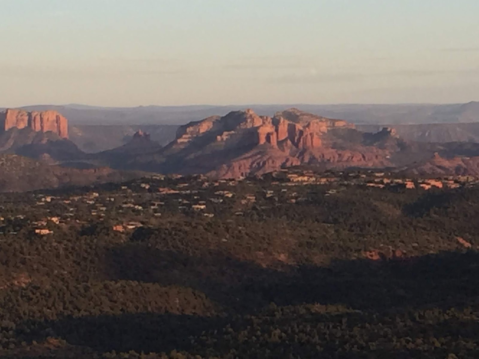
Twenty minutes' drive north from
Cottonwood lies Sedona. Nestled among red Supai sandstone
outcroppings, mesas and buttes, a landscape totally incongruous
compared to the area that surrounds it, Sedona is a tourist haven in
a different way. People come here to hike, mountain-bike, go
off-roading, and generally enjoy the outdoors. With a mixture of
easy and difficult hikes, some accessible from within the town, it
draws weekend fitness freaks from the Phoenix area a mere hour's
drive away, as well as year round visitors from the rest of the USA
and abroad.
It was the hiking that drew us to visit
here. Apart from the walking we did as part of our jobs, we hadn't
been terribly active for a long time. Would we still be fit enough
to complete a four or five mile hike over hilly terrain in 80 F (25C)
heat?
We tried a gentle climb first – a
three mile round trip with an elevation of 500 feet, along the Little
Horse trail, past The Nuns (two sandstone pillars),

to the Chicken Run – a final steeper climb to a flat outcropping with great views. As always in the US there are alternatives for those not inclined to walk. Sedona provides a veritable procession of guided off road tours to take the walking averse to various viewpoints across the three main hiking areas surrounding the town, and we were surprised to find our views from the Chicken Run shared with the contents of two neon pink 12 seater custom built ATVs.
Encouraged by the relative ease of the
hike and no adverse after-effects, we did a total of four hikes
during the week, plus an evening climb to catch the sunset over the
mountains.


Lastly we set our sights higher.
Literally. The Devil's Bridge is a natural bridge (ie created by
water erosion) popular not just for the hike but for the off-roading
trail to get to the rather isolated trail head. We made it more
challenging for ourselves by taking a round about hike to get to the
trail head. The hike is short but steep, with great views of the
valley below. Having got to the top there was really no way I was
not going to join the queue for a unique photo opportunity.

Wait a
minute! Haven't I done that pose before?


Comments
Post a Comment